Introducing DroneNav
DroneNav MapView Illustration
Understanding DroneNav
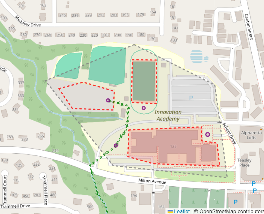
The illustration above demonstrates how DroneNav models and manages low-altitude aviation infrastructure within a geographic area. Each outlined Site represents a managed operating area where aviation activities can be planned and coordinated. Within a Site, Zones define specific operating regions and restrictions that support different types of activities, safety requirements, or operational objectives. Routes establish approved paths between destinations, while DronePorts provide designated locations for launch, landing, staging, and transfer operations.
Core Infrastructure Elements
- Sites - Managed operating areas where aviation infrastructure is planned and governed.
- Zones - Defined operational regions that establish rules, restrictions, or specific uses within a Site.
- Routes - Approved pathways connecting destinations and supporting predictable flight operations.
- DronePorts - Designated locations for launch, landing, staging, and transfer operations.
DroneNav combines these infrastructure elements into a single geospatial platform that allows organizations, communities, and operators to visualize and manage shared airspace. By displaying Sites, Zones, Routes, and DronePorts on a common map, stakeholders can better understand how aviation activities interact with existing communities, transportation corridors, utilities, and other physical infrastructure. This shared operational picture promotes safer planning, improved coordination, and more efficient use of low-altitude airspace.
As autonomous and remotely piloted aircraft become increasingly common, the need for structured aviation infrastructure will continue to grow. DroneNav provides the digital foundation for that infrastructure by enabling the creation, management, and governance of aviation networks that can scale from local operations to regional deployments. The platform is designed to support future integration with flight planning, airspace authorization, operational monitoring, and other services that help organizations safely manage the next generation of low-altitude aviation.
Looking Ahead
DroneNav is continually evolving to support the safe and efficient integration of unmanned aircraft into civilian and commercial airspace. While the examples above introduce the core concepts of Sites, Zones, Routes, and DronePorts, these infrastructure elements serve as the foundation for a much broader aviation network. DroneNav is designed to help communities, operators, and authorities collaboratively plan, govern, and manage the future of low-altitude aviation.
Corridors
Routes define the path along which aircraft may travel. A Corridor extends that concept by establishing operational characteristics for a route, including altitude restrictions, direction of travel, aircraft limitations, speed restrictions, and other operational requirements. Corridors provide a structured framework for organizing air traffic and can be used to create managed aviation networks that separate different classes of operations, such as commercial delivery services, public safety missions, and recreational activities.
Zones and Restricted Areas
Zones define operational areas within a Site and can be used to establish both permitted and restricted airspace. A Zone may prohibit flight activity within a defined area, or it may be designated as an Inclusive Zone that constrains operations to a specific geographic boundary. Additional characteristics, including altitude limits and operational restrictions, allow Zones to support a wide variety of safety, environmental, and operational requirements.
Governance
A successful aviation network requires more than infrastructure; it requires a process for planning, review, and oversight. DroneNav incorporates a governance framework that supports collaboration among planners, operators, subject matter experts, and authorities. Proposed infrastructure can be reviewed, surveyed, refined, and approved before becoming part of an active aviation network, helping ensure that operational decisions are informed, transparent, and accountable.
Flight Planning
DroneNav promotes responsible flight operations by providing a framework for flight planning and operational coordination. Whether supporting recreational users, commercial operators, or public agencies, the platform is designed to simplify the process of registering, reviewing, and managing flight activities. As the platform evolves, flight planning capabilities will integrate with broader airspace management functions to improve visibility and coordination across the network.
Autonomous Aviation
The future of aviation will include increasing levels of autonomy, requiring systems that are interoperable, transparent, and designed for shared use. DroneNav is being developed as a digital infrastructure platform that supports this future by providing a common framework for defining airspace, managing aviation networks, and coordinating operations across diverse aircraft and manufacturers. By emphasizing open standards, governance, and interoperability, DroneNav seeks to provide a foundation for the safe growth of autonomous aviation.
A Letter From The Founder
Read a letter from the founder here.